
Jundah Roadhouse
The Jundah Roadhouse offers:
- Groceries
- Coffee
- Prepared Food
- Unleaded Fuel (Premium & Regular)
- Diesel fuel
Operating hours are as follows:
• Weekdays: 6 AM – 5.30 PM
• Weekends and Public Holidays: 8 AM – 2 PM
Kitchen Operating Hours are as follows:
Weekdays: 6am - 2pm
Weekends and Public Holidays: 8am - 2pm
Fuel is available at the Roadhouse 24 hours a day, 7 days per week.
Swap'N'Go gas is now available!
- Details
Services
- Details
Services
- Details
Services
- Details
About Our Towns
Jundah
Nestled safely above the floodplain of the Thomson River, downstream from Stonehenge, Jundah is the Administration Centre for the Barcoo Shire. Tranquillity is the drawcard, offering a carefree lifestyle abound with country hospitality.
The river so close to town, offers the avid birdwatcher and fisherman the chance to take things easy or if its some physical action your seeking kayak the serene waters. The Settlers' Nature Drive meanders along the river bank before venturing through diverse land types. Plant species are identified along the way.
The Native Well, located 32km north of Jundah on the Stonehenge road, was a valuable water source for indigenous people in days gone by - marvel at how these wells were manually created.
Magee's Shanty (of Banjo Patterson's Bush Christening Fame) lies about 100kms to the south east of the town. Call in at the information centre to ask for directions.
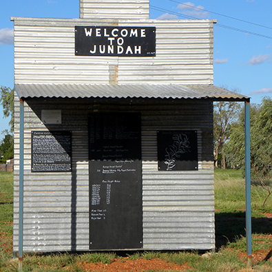
Unique "Welcome Signs" to the town replicate the historic shop front still to be seen in the main street of Jundah. Each of the signs is linked together by a walking trail and contains different information giving an insight into the early years of the township.
One of the most fascinating areas to visit whilst in the Heart of the Channel Country is the 124,000ha Wellford National Park. With its' wide expanses of Spinifex, red sand hills, mulga lands and majestic waterholes the incredible wildlife is in abundance. There are two outstanding drives to take following the Barcoo River, one to the west, the other to the east. Camping is permitted but check with the ranger to aquire your permit and any updates to changes to conditions within the park.
After days exploring or losing the big one that got away, refresh in the swimming pool adjacent to the park - a great way to relax and unwind.
Windorah
Windorah is the Aboriginal word meaning "Big Fish" and is 35km south of where the Thomson and Barcoo Rivers join to form the multi-channelled Cooper Creek which commences its epic journey towards Lake Eyre. Pushing through a mosaic of channels and flood plains that stretch outwards from its banks for up to 100kms, Cooper Creek in flood is surely the beating heart of the Channel Country.
With waterholes spanning up to 10kms in length there is generally great fishing to be had with catches of yellowbelly, catfish and bream. Smaller channels are great for catching fabulous yabbies - one of the great bush delicacies.
A 12km nature drive from just outside town to the Cooper Creek crossing is a must to learn about the huge range of flora native to the area.
The sand hills to the west of town are the deepest red you will ever see. A western sunset over these magnificent hills is very photogenic and there is definitely no shortage of them just a short distance from town on the road to Birdsville.
An original slab hut, circa 1906 built on the banks of the Whitula Creek has been relocated to town and features in an interesting historical display, retelling the history of the town and its people.
80kms west of Windorah lies the JC pub ruins, once part of the township site of Canterbury, and the small town cemetery is a poignant reminder of the vulnerability of our early pioneers and their children in the outback.
Windorah is also now home to an amazing Solar Electricity power plant, and definately worth the stop of generating power fromm the sun, this plant supplies Windorah with most of its energy requirements.
Stonehenge
Situated 151kms from Longreach on the Thomson Development Road, Stonehenge heartily welcomes all visitors. When asked what they most enjoy about Stonehenge, people say the warm welcome and peace and quiet. Chat with the local residents to discover some of the history or follow directions to the John Egan Pioneer Track to see some fantastic landscapes and views.
Situated close to the Thomson River just out of flood reach Stonehenge is the ideal spot to relax for a few days.
To sign the visitors book Stonehenge style, you write your name in stone directly beside the main road not far from town. This tradition started years ago by the then mailman - the rest is history! Take some to to read through the many names and places., but please remember if leaving your mark not to remove stones already in
use.
XXXX Hill is a scenic vantage point with breathtaking 360 degree views of the Thomson River flood plains and surrounding Johnstone Ranges.
Less than 6km from Stonehenge and completely unexpected is a series of magnificent rock holes framed with ghostly white gum trees. Travel along the John Egan Pioneer Drive and discover magnificent landscapes scultured by nature into the most amazing rock formations over millions of years.
A little further towards Jundah, you crest the jump-up and Swanvale Lookout - a fantastic spot to boil the billy with picnic tables & fire places.
Join the locals at the Stonehenge Hotel for lunch and a coll drink, stop over and take your time to explore this magic landscape.
- Details